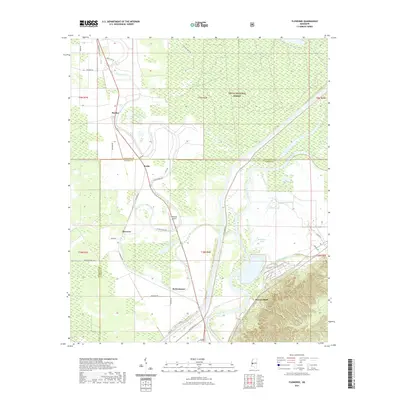
2021 Map of Floweree
USGS Topo · Published 2021About this map
Haynes Bluff stands at the southern edge of this Mississippi Delta landscape, where the floodplain terrain begins its transition. To the north, the Delta National Forest dominates the geography, characterized by a complex network of wetlands and oxbow formations like Hardee Lake and Panther Lake. The Yazoo River defines the eastern corridor, its winding course accompanied by the Levee Maint Rd, which provides critical infrastructure for this low-lying region. Small agricultural settlements and former rail stops including Floweree, Walsh, and Hardee are scattered along the western corridor, often following the path of Deer Creek. The presence of Whitaker Airport and several localized thoroughfares such as Anderson Tully Rd and Simrall Rd illustrate the modern transportation patterns that support the area's timber and farming economies near the Issaquena and Warren county line.
Find a feature on this map
41 named features on this map. Tap any name to fly to it.
Don’t see what you’re looking for? This feature index may not catch every label — zoom into the map to look around manually.
Map Details
Editions of this 2021 Floweree Map
This is the sole edition of this map. No revisions or reprints were ever made.
Other maps of this area

1918 · Vicksburg
USGS Topo · 1:62,500

1938 · Edwards
USGS Topo · 1:62,500

1939 · Onward
USGS Topo · 1:62,500

1940 · Mechanicsburg
USGS Topo · 1:62,500

1941 · Vicksburg
USGS Topo · 1:62,500

1955 · Jackson
USGS Topo · 1:250,000

1961 · Jackson
USGS Topo · 1:250,000

1962 · Jackson
USGS Topo · 1:250,000

1962 · Redwood
USGS Topo · 1:24,000
1962 · Long Lake
USGS Topo · 1:24,000