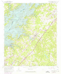
1964 Map of Flowery Branch
USGS Topo · Published 1975About this map
Lake Sidney Lanier dominates the western landscape of this Hall County region, its irregular shoreline creating a complex network of bays and access points such as Williams Ferry Access Point and Vanns Tavern Access Point. The expansion of the lake changed the local geography significantly, submerging portions of the Chattahoochee River valley and creating secluded waterfront pockets like Flowery Branch Bay and Chattahoochee Bay. On the eastern shore, the town of Flowery Branch serves as a central hub, situated along the Southern railroad line which runs parallel to the rolling topography of Chestnut Ridge.
Find a feature on this map
58 named features on this map. Tap any name to fly to it.
Don’t see what you’re looking for? This feature index may not catch every label — zoom into the map to look around manually.
Map Details
Editions of this 1964 Flowery Branch Map
4 editions found
Other maps of this area

1890 · Suwanee
USGS Topo · 1:125,000

1891 · Gainesville
USGS Topo · 1:125,000

1894 · Suwanee
USGS Topo · 1:125,000

1954 · Greenville
USGS Topo · 1:250,000

1955 · Rome
USGS Topo · 1:250,000

1958 · Greenville
USGS Topo · 1:250,000

1958 · Rome
USGS Topo · 1:250,000

1961 · Rome
USGS Topo · 1:250,000

1963 · Rome
USGS Topo · 1:250,000

1964 · Hog Mountain
USGS Topo · 1:24,000