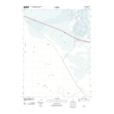
2011 Map of Flux
USGS Topo · Published 2011About this map
Tooele Valley serves as the backdrop for this study of industrial and natural transitions in northern Utah. The landscape is defined by the proximity of the Stansbury Mountains and the lower basin leading toward the Great Salt Lake, featuring the namesake settlement of Flux and the nearby Dolomite. These locations, alongside the Monte Carlo Mine and Utah Bunker Hill Mine, underscore the region's historical ties to mineral extraction and limestone quarrying. Modern infrastructure intersects with early transcontinental travel routes here, most notably where the Old Lincoln Hwy skirts the edge of Little Mountain. Hydrological features like the Warm Springs Slough and Warm Springs indicate the unique environmental conditions of the valley floor, where seasonal water and marshes break the arid terrain of Timpie Valley and the rugged cuts of Miners Canyon.
Find a feature on this map
17 named features on this map. Tap any name to fly to it.
Don’t see what you’re looking for? This feature index may not catch every label — zoom into the map to look around manually.
Map Details
Editions of this 2011 Flux Map
This is the sole edition of this map. No revisions or reprints were ever made.
Other maps of this area

1885 · Tooele Valley
USGS Topo · 1:250,000

1953 · Tooele
USGS Topo · 1:250,000

1955 · Timpie
USGS Topo · 1:62,500

1955 · Burmester
USGS Topo · 1:24,000

1955 · Grantsville
USGS Topo · 1:24,000

1955 · Tooele
USGS Topo · 1:250,000

1968 · Poverty Point
USGS Topo · 1:24,000

1968 · Corral Canyon
USGS Topo · 1:24,000
1968 · Plug Peak
USGS Topo · 1:24,000
1972 · Burmester
USGS Topo · 1:24,000