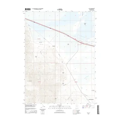
2014 Map of Flux
USGS Topo · Published 2014About this map
The Stansbury Mountains rise sharply above the west side of the Tooele Valley, defining a landscape where steep canyons meet the low-lying wetlands of the Great Salt Lake basin. Settlements such as Dolomite and Flux are situated along the base of these peaks, reflecting the region's industrial ties to mining and mineral extraction. This geography is further illustrated by features like Miners Canyon and Kimball Canyon, which cut through the high terrain above Timpie Valley. To the northeast, the terrain flattens toward Stansbury Bay, where the Stansbury Island Bar and Warm Springs Slough create a complex marshland environment. Modern transit corridors follow legacy routes, including segments of the Old Lincoln Hwy passing through the outskirts of Grantsville, showing how historical transport patterns continue to shape the modern infrastructure of Tooele County.
Find a feature on this map
26 named features on this map. Tap any name to fly to it.
Don’t see what you’re looking for? This feature index may not catch every label — zoom into the map to look around manually.
Map Details
Editions of this 2014 Flux Map
This is the sole edition of this map. No revisions or reprints were ever made.
Other maps of this area

1885 · Tooele Valley
USGS Topo · 1:250,000

1953 · Tooele
USGS Topo · 1:250,000

1955 · Timpie
USGS Topo · 1:62,500

1955 · Burmester
USGS Topo · 1:24,000

1955 · Grantsville
USGS Topo · 1:24,000

1955 · Tooele
USGS Topo · 1:250,000

1968 · Poverty Point
USGS Topo · 1:24,000

1968 · Corral Canyon
USGS Topo · 1:24,000
1968 · Plug Peak
USGS Topo · 1:24,000
1972 · Burmester
USGS Topo · 1:24,000