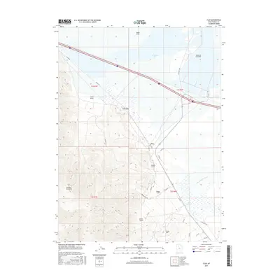
2017 Map of Flux
USGS Topo · Published 2017About this map
Dolomite and Flux sit at the transition where the eastern slopes of the Stansbury Mountains meet the floor of the Tooele Valley. This 2017 landscape is defined by its industrial and transportation corridors, featuring the historic route of the Old Lincoln Hwy and the expansive Salt Rd. To the north, the terrain gives way to the wetlands of Stansbury Bay and the distinctive Stansbury Island Bar, while the southeastern corner is dominated by the marshy reaches of Warm Springs Slough. Numerous canyons, including Miners Canyon and Broad Canyon, drain the high ridges of the Stansbury range, illustrating the complex drainage patterns that feed into the Warm Springs area. The presence of specialized roads like Dolomite Rd and Mistway Rd reflects the local land use and infrastructure supporting these small settlements at the edge of the salt flats.
Find a feature on this map
34 named features on this map. Tap any name to fly to it.
Don’t see what you’re looking for? This feature index may not catch every label — zoom into the map to look around manually.
Map Details
Editions of this 2017 Flux Map
This is the sole edition of this map. No revisions or reprints were ever made.
Other maps of this area

1885 · Tooele Valley
USGS Topo · 1:250,000

1953 · Tooele
USGS Topo · 1:250,000

1955 · Timpie
USGS Topo · 1:62,500

1955 · Burmester
USGS Topo · 1:24,000

1955 · Grantsville
USGS Topo · 1:24,000

1955 · Tooele
USGS Topo · 1:250,000

1968 · Poverty Point
USGS Topo · 1:24,000

1968 · Corral Canyon
USGS Topo · 1:24,000
1968 · Plug Peak
USGS Topo · 1:24,000
1972 · Burmester
USGS Topo · 1:24,000