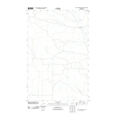
2011 Map of Flynn Creek North
USGS Topo · Published 2011About this map
The high plains of Roosevelt County are defined by a network of drainage systems feeding toward the Missouri River valley. This digital-era survey highlights the hydrology of the Wolf Point District, where the branched tributaries of Flynn Creek and its East Fork cut through the Montana landscape. The geography is characterized by its distinct coulees and intermittent watercourses, most notably the wide drainage of Wolf Creek and the curiously named Badger Hole Coulee in the northeast. Transportation across this stretch of the northern plains is anchored by Wolf Creek Rd, which tracks the southern portion of the quadrangle. The map also records the winding path of Littleman Creek, providing a clear record of the watershed and local land divisions as they existed at the start of the 2010s.
Find a feature on this map
6 named features on this map. Tap any name to fly to it.
Don’t see what you’re looking for? This feature index may not catch every label — zoom into the map to look around manually.
Map Details
Editions of this 2011 Flynn Creek North Map
This is the sole edition of this map. No revisions or reprints were ever made.
Other maps of this area

1910 · Todd Lakes
USGS Topo · 1:62,500

1915 · Tule Valley
USGS Topo · 1:62,500

1915 · Oswego
USGS Topo · 1:62,500

1915 · Todd Lakes
USGS Topo · 1:62,500

1916 · Wolf Point
USGS Topo · 1:62,500

1954 · Wolf Point
USGS Topo · 1:250,000

1958 · Wolf Point
USGS Topo · 1:250,000

1972 · Flynn Creek North
USGS Topo · 1:24,000

1972 · Wolf Point
USGS Topo · 1:24,000
1972 · Flynn Creek South
USGS Topo · 1:24,000