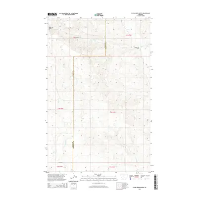
2014 Map of Flynn Creek North
USGS Topo · Published 2014About this map
Valley County and Roosevelt County meet along a straight north-south line in this 2014 study of the northeastern Montana plains. The landscape is defined by the headwaters and drainage basins of several prairie waterways, most notably Flynn Creek and its tributary, East Fork Flynn Creek. These drainages have carved distinct relief into the terrain, including the deeply etched Badger Hole Coulee in the northwest. In a region where water is a vital resource, the locations of 29N45E26DCBD01 Spring and 29N45E36BAAA01 Spring are meticulously recorded. Settlement is sparse, with human presence marked primarily by the grid of local roads such as Nygaard Road and the larger north-south thoroughfare of CR-1078 near the eastern boundary.
Find a feature on this map
16 named features on this map. Tap any name to fly to it.
Don’t see what you’re looking for? This feature index may not catch every label — zoom into the map to look around manually.
Map Details
Editions of this 2014 Flynn Creek North Map
This is the sole edition of this map. No revisions or reprints were ever made.
Other maps of this area

1910 · Todd Lakes
USGS Topo · 1:62,500

1915 · Tule Valley
USGS Topo · 1:62,500

1915 · Oswego
USGS Topo · 1:62,500

1915 · Todd Lakes
USGS Topo · 1:62,500

1916 · Wolf Point
USGS Topo · 1:62,500

1954 · Wolf Point
USGS Topo · 1:250,000

1958 · Wolf Point
USGS Topo · 1:250,000

1972 · Flynn Creek North
USGS Topo · 1:24,000

1972 · Wolf Point
USGS Topo · 1:24,000
1972 · Flynn Creek South
USGS Topo · 1:24,000