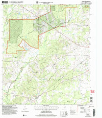
2004 Map of Fodice
USGS Topo · Published 2006About this map
Davy Crockett National Forest dominates this landscape in East Texas, where the piney woods meet the headwaters of numerous drainages. Small rural settlements like Fodice and Holly anchor the local geography, surrounded by a network of country churches including White Rock Ch and Mt Pleasant Ch. This area on the Houston and Trinity County line is defined by its deep creek system, with White Rock Creek and Dickey Creek carving through the wooded terrain. For the genealogist, the map details several burial grounds such as Fodice Cem and Foster Cem, which reflect the long-standing community centers of the region. The map also shows Plainview and Shady Grove on the northern edge of the national forest boundary, illustrating the rural residential patterns that persisted into the early 21st century.
Find a feature on this map
25 named features on this map. Tap any name to fly to it.
Don’t see what you’re looking for? This feature index may not catch every label — zoom into the map to look around manually.
Map Details
Editions of this 2004 Fodice Map
This is the sole edition of this map. No revisions or reprints were ever made.
Other maps of this area

1950 · Crockett
USGS Topo · 1:24,000

1951 · Crockett
USGS Topo · 1:24,000

1951 · Kennard
USGS Topo · 1:24,000

1951 · Berea
USGS Topo · 1:24,000

1953 · Palestine
USGS Topo · 1:250,000

1957 · Palestine
USGS Topo · 1:250,000

1962 · Lovelady South
USGS Topo · 1:24,000

1962 · Glendale
USGS Topo · 1:24,000

1963 · Lovelady North
USGS Topo · 1:24,000

1963 · Groveton West
USGS Topo · 1:24,000