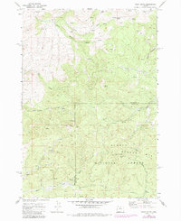
1969 Map of Foley Butte
USGS Topo · Published 1985About this map
Ochocco National Forest dominates this Central Oregon landscape, where the high-elevation terrain of the Maury Mountains is defined by sharp volcanic features and vital water sources. The map centers on Foley Butte, which stands as a prominent high point crowned with a Lookout Tower for fire observation. Steep drainages like Little Willow Creek and Awbrey Creek carve through the timbered slopes, while named landmarks such as Sheep Rock and Awbrey Mtn provide essential orientation for early forest navigation.
Find a feature on this map
20 named features on this map. Tap any name to fly to it.
Don’t see what you’re looking for? This feature index may not catch every label — zoom into the map to look around manually.
Map Details
Editions of this 1969 Foley Butte Map
2 editions found
Other maps of this area

1948 · Ochoco Reservoir
USGS Topo · 1:62,500

1950 · Ochoco Reservoir
USGS Topo · 1:62,500

1955 · Bend
USGS Topo · 1:250,000

1957 · Bend
USGS Topo · 1:250,000

1958 · Bend
USGS Topo · 1:250,000

1962 · Prineville
USGS Topo · 1:62,500

1968 · Axehandle Butte
USGS Topo · 1:24,000

1968 · Dutchman Creek
USGS Topo · 1:24,000

1968 · Ashwood
USGS Topo · 1:24,000
1969 · Brewer Reservoir
USGS Topo · 1:24,000