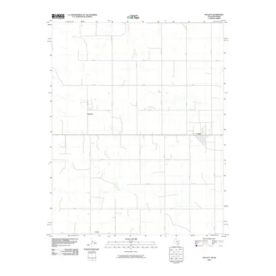
2010 Map of Follett
USGS Topo · Published 2010About this map
The town of Follett anchors this northeastern Lipscomb County survey, appearing as a developed grid at the intersection of local routes and the northern borderlands. The landscape is defined by the dendritic patterns of several waterways, including Indian Creek in the north and the winding course of Mammoth Creek which traverses the southern half of the map. This 2010 study reveals a region organized by an extensive network of rural roads, such as Co Rd 20 and Co Rd C, facilitating transport across the Panhandle's agricultural plains. Genealogy researchers will find the Fairview Cemetery positioned in the southwestern portion of the map near Sherlock, a smaller settlement cluster that stands alongside several drainage tributaries. The survey captures a moment of modern infrastructure superimposed on a classic Texas high plains drainage system, where intermittent streams like Ivanhoe Creek shape the local topography.
Find a feature on this map
23 named features on this map. Tap any name to fly to it.
Don’t see what you’re looking for? This feature index may not catch every label — zoom into the map to look around manually.
Map Details
Editions of this 2010 Follett Map
This is the sole edition of this map. No revisions or reprints were ever made.
Other maps of this area

1954 · Perryton
USGS Topo · 1:250,000

1958 · Perryton
USGS Topo · 1:250,000

1971 · Clear Lake SE
USGS Topo · 1:24,000

1971 · Logan
USGS Topo · 1:24,000

1971 · Slapout
USGS Topo · 1:24,000

1972 · Follett SE
USGS Topo · 1:24,000

1972 · Dugout Creek
USGS Topo · 1:24,000

1972 · Skunk Creek
USGS Topo · 1:24,000
1972 · Magoun
USGS Topo · 1:24,000

1972 · Follett
USGS Topo · 1:24,000