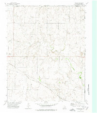
1972 Map of Magoun
USGS Topo · Published 1974About this map
Magoun sits at the southern edge of this High Plains landscape, where the Atchison Topeka and Santa Fe railroad cuts a diagonal path across the terrain. The map documents a sparsely populated ranching and energy-producing region along the border of Beaver and Ellis counties in Oklahoma and Lipscomb County in Texas. Infrastructure for the regional petroleum industry is evident through numerous Gas Wells and several Pipeline corridors that crisscross the prairie. For genealogists and local historians, the Fairmont Cem and a Roadside Park provide specific points of reference in an area otherwise defined by drainage patterns like Ivanhoe Creek. The presence of the County Airport near the western margin suggests the mid-century development of local transit and utility for the surrounding rural community.
Find a feature on this map
16 named features on this map. Tap any name to fly to it.
Don’t see what you’re looking for? This feature index may not catch every label — zoom into the map to look around manually.
Map Details
Editions of this 1972 Magoun Map
This is the sole edition of this map. No revisions or reprints were ever made.
Other maps of this area

1954 · Perryton
USGS Topo · 1:250,000

1955 · Woodward
USGS Topo · 1:250,000

1958 · Perryton
USGS Topo · 1:250,000

1958 · Woodward
USGS Topo · 1:250,000

1969 · Shattuck
USGS Topo · 1:24,000

1969 · Shattuck NW
USGS Topo · 1:24,000

1970 · Laverne SW
USGS Topo · 1:24,000

1971 · Logan
USGS Topo · 1:24,000

1971 · Slapout
USGS Topo · 1:24,000

1972 · Follett SE
USGS Topo · 1:24,000