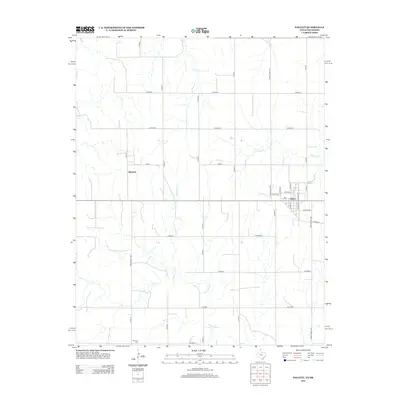
2012 Map of Follett
USGS Topo · Published 2012About this map
Follett anchor the southeastern corner of this High Plains landscape, where the town's grid is defined by streets like Potter St and S Main St. The surrounding terrain in the Texas Panhandle is deeply etched by a series of intermittent waterways, including Indian Cr, Ivanhoe Cr, and the winding path of Mammoth Cr. These drainage systems create a distinct North-South texture against the rigid square-mile grid of the regional road system. To the west, the locality of Sherlock sits near the intersection of several county roads, while the southern reaches of the quadrangle house the Fairview Cem. The map illustrates the transition from the town center, with residential ways such as Lovers Ln and Pine Ave, into the broader agricultural expanses served by Ranch Road 2741 and numerous numbered county routes.
Find a feature on this map
31 named features on this map. Tap any name to fly to it.
Don’t see what you’re looking for? This feature index may not catch every label — zoom into the map to look around manually.
Map Details
Editions of this 2012 Follett Map
This is the sole edition of this map. No revisions or reprints were ever made.
Other maps of this area

1954 · Perryton
USGS Topo · 1:250,000

1958 · Perryton
USGS Topo · 1:250,000

1971 · Clear Lake SE
USGS Topo · 1:24,000

1971 · Logan
USGS Topo · 1:24,000

1971 · Slapout
USGS Topo · 1:24,000

1972 · Follett SE
USGS Topo · 1:24,000

1972 · Dugout Creek
USGS Topo · 1:24,000

1972 · Skunk Creek
USGS Topo · 1:24,000
1972 · Magoun
USGS Topo · 1:24,000

1972 · Follett
USGS Topo · 1:24,000