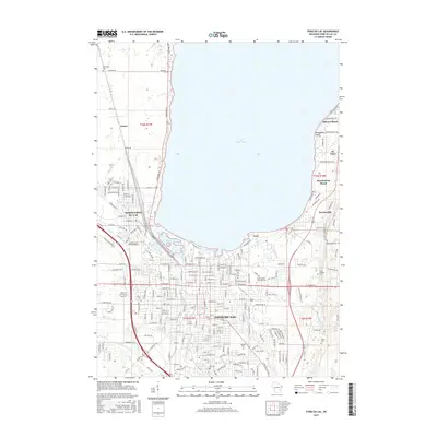
2015 Map of Fond du Lac
USGS Topo · Published 2015About this map
Lake Winnebago defines the northern horizon of this landscape, where the Fond du Lac River and several smaller tributaries like De Neveu Creek and Luco Cr converge. The city of Fond du Lac occupies the southern shore, showing a dense grid of residential and commercial development that transitions into the neighboring communities of North Fond du Lac and Taycheedah. The presence of Marian Univ and Moraine Park Technical Coll marks the area as a regional educational hub, while the Fond du Lac County Airport at the western edge highlights its role as a transportation center.
Find a feature on this map
217 named features on this map. Tap any name to fly to it.
Don’t see what you’re looking for? This feature index may not catch every label — zoom into the map to look around manually.
Map Details
Editions of this 2015 Fond du Lac Map
This is the sole edition of this map. No revisions or reprints were ever made.
Other maps of this area

1910 · Fond du Lac
USGS Topo · 1:62,500

1955 · Waupun
USGS Topo · 1:62,500

1955 · Campbellsport
USGS Topo · 1:62,500

1955 · Fond Du Lac
USGS Topo · 1:62,500

1955 · Fond Du Lac
USGS Topo · 1:24,000

1956 · Rosendale
USGS Topo · 1:62,500

1957 · Madison
USGS Topo · 1:250,000

1960 · Madison
USGS Topo · 1:250,000
1974 · St. Peter
USGS Topo · 1:24,000
1974 · Fahrney Point
USGS Topo · 1:24,000