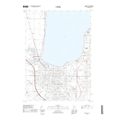
2018 Map of Fond du Lac
USGS Topo · Published 2018About this map
Lake Winnebago defines the northern boundary of this detailed study of Fond Du Lac and its surrounding lakeside communities. The city is positioned at the convergence of the East Branch Fond du Lac River and West Branch Fond du Lac River, a geographic focal point that shaped the area's development. To the north and east, residential developments and recreational areas like Minawa Beach and Hopokoekau Beach line the shore, while the Supple Marsh provides a transition between the urban grid and the lake waters.
Find a feature on this map
147 named features on this map. Tap any name to fly to it.
Don’t see what you’re looking for? This feature index may not catch every label — zoom into the map to look around manually.
Map Details
Editions of this 2018 Fond du Lac Map
This is the sole edition of this map. No revisions or reprints were ever made.
Other maps of this area

1910 · Fond du Lac
USGS Topo · 1:62,500

1955 · Waupun
USGS Topo · 1:62,500

1955 · Campbellsport
USGS Topo · 1:62,500

1955 · Fond Du Lac
USGS Topo · 1:62,500

1955 · Fond Du Lac
USGS Topo · 1:24,000

1956 · Rosendale
USGS Topo · 1:62,500

1957 · Madison
USGS Topo · 1:250,000

1960 · Madison
USGS Topo · 1:250,000
1974 · St. Peter
USGS Topo · 1:24,000
1974 · Fahrney Point
USGS Topo · 1:24,000