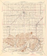
1943 Map of Fontana
USGS Topo · Published 1943About this map
The Jurupa Mountains dominate the southern portion of this landscape, separating the developing citrus and vineyard belts from the industrial and riverine corridors of the Santa Ana River. At this time, Fontana and Rialto are organized around a strict grid of avenues and boulevards like Foothill Boulevard and Arrow Highway, served by a dense network of competing rail lines including the Pacific Electric, Southern Pacific, and the Atchison Topeka and Santa Fe.
Find a feature on this map
46 named features on this map. Tap any name to fly to it.
Don’t see what you’re looking for? This feature index may not catch every label — zoom into the map to look around manually.
Map Details
Editions of this 1943 Fontana Map
3 editions found
Other maps of this area

1896 · San Bernardino
USGS Topo · 1:62,500

1897 · Cucamonga
USGS Topo · 1:62,500

1898 · San Bernardino
USGS Topo · 1:62,500

1900 · Cucamonga
USGS Topo · 1:62,500

1901 · Southern California Sheet No. 1
USGS Topo · 1:250,000

1901 · San Bernardino
USGS Topo · 1:62,500

1901 · Elsinore
USGS Topo · 1:125,000

1901 · Riverside
USGS Topo · 1:62,500

1902 · Corona
USGS Topo · 1:125,000

1903 · Cucamonga
USGS Topo · 1:62,500