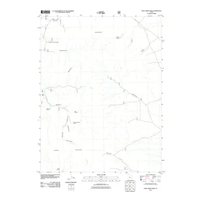
2011 Map of Fool Creek Peak
USGS Topo · Published 2011About this map
Fool Creek Peak rises as the dominant landmark in this part of Millard County, overlooking a network of deep drainages and isolated water sources. This 2011 survey illustrates the complex hydrology of the high country, where seasonal flows like Dry Fork and Fool Creek are punctuated by critical watering points such as Pipe Spring, Black Willow Spring, and Mourning Dove Spring. The terrain is characterized by dramatic elevation shifts and narrow passages, most notably at The Narrows and throughout the various named canyons like Little Wild Horse Canyon and Charley Johnson Canyon. Evidence of past land use or historical activity is suggested by place names such as Mine Hollow and Mill Canyon, while Leamington Pass Rd provides the primary access route through this high-altitude environment. The map offers a precise view of the topography surrounding Wild Horse Peak and Buck Peak, essential for understanding the livestock and recreational history of the region.
Find a feature on this map
28 named features on this map. Tap any name to fly to it.
Don’t see what you’re looking for? This feature index may not catch every label — zoom into the map to look around manually.
Map Details
Editions of this 2011 Fool Creek Peak Map
This is the sole edition of this map. No revisions or reprints were ever made.
Other maps of this area

1885 · Sevier Desert
USGS Topo · 1:250,000

1951 · Oak City
USGS Topo · 1:62,500

1952 · Scipio North
USGS Topo · 1:62,500

1953 · Delta
USGS Topo · 1:250,000

1958 · Delta
USGS Topo · 1:250,000

1962 · Delta
USGS Topo · 1:250,000

1962 · Lynndyl
USGS Topo · 1:62,500

1967 · Champlin Peak
USGS Topo · 1:24,000
1967 · Sage Valley
USGS Topo · 1:24,000

1979 · Lynndyl
USGS Topo · 1:100,000