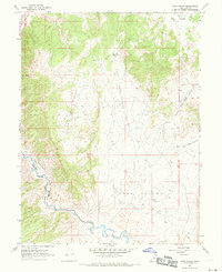
1967 Map of Sage Valley
USGS Topo · Published 1969About this map
The Sevier River winds through the southwestern corner of this mid-1960s survey, following the natural passage of Sevier Canyon. Parallel to the water, the Union Pacific tracks represent the primary transportation artery through this corridor of Juab County. The landscape is defined by the broad expanse of Sage Valley and the smaller Little Sage Valley to the west, separated by high terrain marked with a Quarry and scattered Prospects. In the northern uplands, the West Fork Reservoir sits at the head of the West Fork Sage Valley. The drainage system is clearly articulated through features like Dog Valley Wash and the distinct Middle and East forks of the valley, reflecting a rural Utah landscape dedicated to ranching and resource extraction.
Find a feature on this map
19 named features on this map. Tap any name to fly to it.
Don’t see what you’re looking for? This feature index may not catch every label — zoom into the map to look around manually.
Map Details
Editions of this 1967 Sage Valley Map
This is the sole edition of this map. No revisions or reprints were ever made.
Other maps of this area

1885 · Manti
USGS Topo · 1:250,000

1885 · Sevier Desert
USGS Topo · 1:250,000

1895 · Manti
USGS Topo · 1:250,000

1951 · Nephi
USGS Topo · 1:62,500

1952 · Scipio North
USGS Topo · 1:62,500

1953 · Delta
USGS Topo · 1:250,000

1956 · Price
USGS Topo · 1:250,000

1958 · Delta
USGS Topo · 1:250,000

1960 · Price
USGS Topo · 1:250,000

1962 · Price
USGS Topo · 1:250,000