
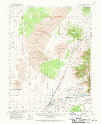
1962 Map of Lynndyl
USGS Topo · Published 1963About this map
Lynndyl and Leamington serve as the primary hubs of activity in this 1962 landscape, where the Union Pacific railroad tracks provide a vital artery through the desert terrain. The area is defined by the contrast between the shifting Sand Dunes and Sand Hills to the north and the irrigation-dependent agriculture along the Sevier River to the south. Local water management is visible through the engineering of the Utah Central Canal and various unnamed ditches that supported the small settlements of Mack and Leamington.
Find a feature on this map
35 named features on this map. Tap any name to fly to it.
Don’t see what you’re looking for? This feature index may not catch every label — zoom into the map to look around manually.
Map Details
Editions of this 1962 Lynndyl Map
2 editions found
Other maps of this area

1885 · Sevier Desert
USGS Topo · 1:250,000

1951 · Oak City
USGS Topo · 1:62,500

1952 · Scipio North
USGS Topo · 1:62,500

1953 · Delta
USGS Topo · 1:250,000

1954 · Mc Intyre
USGS Topo · 1:24,000

1958 · Delta
USGS Topo · 1:250,000

1962 · Delta
USGS Topo · 1:250,000

1962 · Delta
USGS Topo · 1:62,500

1963 · Maple Peak
USGS Topo · 1:24,000

1963 · Cherry Creek
USGS Topo · 1:24,000