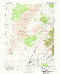
1962 Map of Lynndyl
USGS Topo · Published 1970About this map
The Sevier River carves through the southeast corner of this desert landscape, providing a critical water source for the settlement at Leamington and the railroad hub of Lynndyl. This 1962 survey reveals a land defined by stark contrasts, where the lush riparian corridor supported by the Central Utah Canal and Macks Ditch meets the expansive Sand Dunes and the prominent heights of Sand Mtn. The Union Pacific railroad serves as the primary industrial artery, following the river valley through Leamington Canyon toward the high desert flats.
Find a feature on this map
34 named features on this map. Tap any name to fly to it.
Don’t see what you’re looking for? This feature index may not catch every label — zoom into the map to look around manually.
Map Details
Editions of this 1962 Lynndyl Map
2 editions found
Other maps of this area

1885 · Sevier Desert
USGS Topo · 1:250,000

1951 · Oak City
USGS Topo · 1:62,500

1952 · Scipio North
USGS Topo · 1:62,500

1953 · Delta
USGS Topo · 1:250,000

1954 · Mc Intyre
USGS Topo · 1:24,000

1958 · Delta
USGS Topo · 1:250,000

1962 · Delta
USGS Topo · 1:250,000

1962 · Lynndyl
USGS Topo · 1:62,500

1962 · Delta
USGS Topo · 1:62,500

1963 · Maple Peak
USGS Topo · 1:24,000