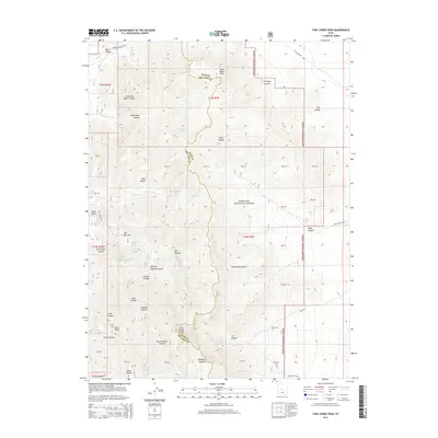
2014 Map of Fool Creek Peak
USGS Topo · Published 2014About this map
Fool Creek Peak dominates this high-elevation terrain within the Fishlake National Forest, where the rugged Canyon Mountains divide Juab and Millard counties. The landscape is defined by a complex network of steep drainages including Pass Canyon, Mill Canyon, and North Walker Canyon. This 2014 survey records essential water sources for the region, such as Wildhorse Spring, Mourning Dove Spring, and Black Willow Spring, which have long been vital for both wildlife and high-country livestock. Local landmarks like The Narrows and Enoch Point provide navigational reference points across the ridges. Early transportation routes are represented by the Leamington Pass Rd, which crosses the northern section at Leamington Pass, while the presence of Mine Hollow suggests the history of resource exploration in these mountains.
Find a feature on this map
47 named features on this map. Tap any name to fly to it.
Don’t see what you’re looking for? This feature index may not catch every label — zoom into the map to look around manually.
Map Details
Editions of this 2014 Fool Creek Peak Map
This is the sole edition of this map. No revisions or reprints were ever made.
Other maps of this area

1885 · Sevier Desert
USGS Topo · 1:250,000

1951 · Oak City
USGS Topo · 1:62,500

1952 · Scipio North
USGS Topo · 1:62,500

1953 · Delta
USGS Topo · 1:250,000

1958 · Delta
USGS Topo · 1:250,000

1962 · Delta
USGS Topo · 1:250,000

1962 · Lynndyl
USGS Topo · 1:62,500

1967 · Champlin Peak
USGS Topo · 1:24,000
1967 · Sage Valley
USGS Topo · 1:24,000

1979 · Lynndyl
USGS Topo · 1:100,000