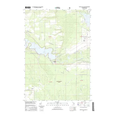
2017 Map of Foote Site Village
USGS Topo · Published 2017About this map
The Au Sable River winds through the heart of this landscape, its path significantly altered by the impoundment at Foote Dam Pond. This 2017 survey details the area around Foote Site Village and Wilber, showing the intersection of recreational trails and heavy-duty infrastructure. Much of the southern and central terrain is preserved within the Huron National Forest, where a complex network of equestrian and hiking paths like the Mi Shore to Shore Horse&Hike and Oscoda-Alcona Smt Dnr96 cut through the timber. To the northeast, the Oscoda-Wurtsmith Airport and the southern tip of Van Etten Lake signal the transition toward more developed coastal zones. Local history is anchored by features like the Chippewa Cem and a series of agricultural drainage systems including State Ditch and Tuttle Ditch.
Find a feature on this map
60 named features on this map. Tap any name to fly to it.
Don’t see what you’re looking for? This feature index may not catch every label — zoom into the map to look around manually.
Map Details
Editions of this 2017 Foote Site Village Map
This is the sole edition of this map. No revisions or reprints were ever made.
Other maps of this area

1954 · Tawas City
USGS Topo · 1:250,000

1958 · Tawas City
USGS Topo · 1:250,000

1959 · Tawas City
USGS Topo · 1:62,500

1959 · East Tawas
USGS Topo · 1:62,500

1959 · Glennie
USGS Topo · 1:62,500

1959 · Harrisville
USGS Topo · 1:62,500

1983 · Hubbard Lake
USGS Topo · 1:100,000

1984 · Tawas City
USGS Topo · 1:100,000

1989 · Mikado
USGS Topo · 1:24,000
1989 · Greenbush
USGS Topo · 1:24,000