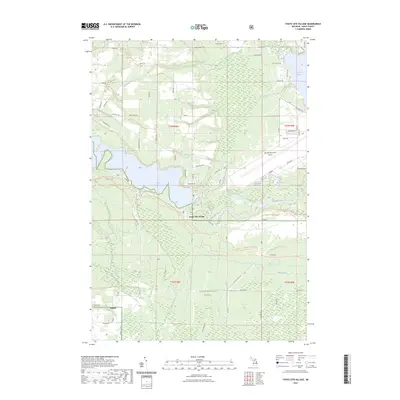
2023 Map of Foote Site Village
USGS Topo · Published 2023About this map
The Au Sable River winds through this landscape in Iosco County, Michigan, defining a region where recreation and natural resources converge. This survey shows the transition from the managed waters of the Foote Dam Pond to the open marshes of the Huron National Forest. The settlement of Foote Site Village is positioned along the riverbanks, serving as a gateway to the diverse hydrological features nearby, including Tuttle Marsh, Allen Lake, and Tuttle Ditch.
Find a feature on this map
74 named features on this map. Tap any name to fly to it.
Don’t see what you’re looking for? This feature index may not catch every label — zoom into the map to look around manually.
Map Details
Editions of this 2023 Foote Site Village Map
This is the sole edition of this map. No revisions or reprints were ever made.
Other maps of this area

1954 · Tawas City
USGS Topo · 1:250,000

1958 · Tawas City
USGS Topo · 1:250,000

1959 · Tawas City
USGS Topo · 1:62,500

1959 · East Tawas
USGS Topo · 1:62,500

1959 · Glennie
USGS Topo · 1:62,500

1959 · Harrisville
USGS Topo · 1:62,500

1983 · Hubbard Lake
USGS Topo · 1:100,000

1984 · Tawas City
USGS Topo · 1:100,000

1989 · Mikado
USGS Topo · 1:24,000
1989 · Greenbush
USGS Topo · 1:24,000