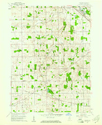
1960 Map of Foraker
USGS Topo · Published 1961About this map
Yellow Creek and its many tributaries, including Little Yellow Creek and Owl Creek, dominate the central drainage of this Elkhart County landscape. The area is characterized by an extensive network of man-made waterways like Fulmer Ditch and Martin Ditch, illustrating the engineered nature of Indiana farmland in the mid-20th century. Cultural life is anchored by numerous rural congregations such as Bethel Ch, St Johns Ch, and the Old Fundamental Ch, alongside family-named burial grounds like Stutzman Cem and Wenger Cem. Transportation and community hubs appear at Midway, situated near the Midway Airport and a Drive-in Theater, and at Foraker further south. The New York Central railroad cuts through the northeastern corner, following the path of the Elkhart River near the Bashor Childrens Home.
Find a feature on this map
51 named features on this map. Tap any name to fly to it.
Don’t see what you’re looking for? This feature index may not catch every label — zoom into the map to look around manually.
Map Details
Editions of this 1960 Foraker Map
4 editions found
Other maps of this area

1951 · Milford
USGS Topo · 1:24,000

1953 · Fort Wayne
USGS Topo · 1:250,000

1953 · Chicago
USGS Topo · 1:250,000

1956 · Fort Wayne
USGS Topo · 1:250,000

1957 · Chicago
USGS Topo · 1:250,000

1958 · Nappanee West
USGS Topo · 1:24,000

1958 · Osceola
USGS Topo · 1:24,000

1958 · Nappanee East
USGS Topo · 1:24,000

1959 · Goshen
USGS Topo · 1:24,000

1960 · Foraker
USGS Topo · 1:24,000