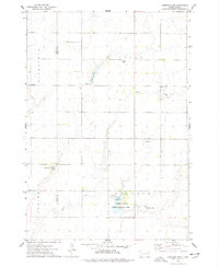
1973 Map of Fordham Dam
USGS Topo · Published 1978About this map
Clark Colony and Huron Colony define the settlement pattern of this rural landscape along the border of Spink and Clark Counties. Surveyed in the early 1970s, the map illustrates a highly organized agricultural and water-management system focused on Foster Creek. Significant infrastructure includes Logan Dam and Fordham Dam, which control water flow across the prairie. The southern portion of the sheet is dominated by the Fordham State Public Shooting Area, a major public land designation highlighting the region's importance for wildlife and recreation. Local civic life is marked by the presence of a rural Townhall and the Logan Cem, while economic activity is indicated by a Gravel Pit and scattered wells. The township boundaries of Richfield, Logan, Capitola, and Fordham provide the underlying administrative structure for these dispersed communities.
Find a feature on this map
15 named features on this map. Tap any name to fly to it.
Don’t see what you’re looking for? This feature index may not catch every label — zoom into the map to look around manually.
Map Details
Editions of this 1973 Fordham Dam Map
This is the sole edition of this map. No revisions or reprints were ever made.
Other maps of this area

1895 · Byron
USGS Topo · 1:125,000

1953 · Huron
USGS Topo · 1:250,000

1953 · Watertown
USGS Topo · 1:250,000

1954 · Huron
USGS Topo · 1:250,000

1958 · Watertown
USGS Topo · 1:250,000
1971 · Doland
USGS Topo · 1:24,000
1971 · Doland SE
USGS Topo · 1:24,000
1971 · Bloomfield
USGS Topo · 1:25,000
1973 · Baileys Lake
USGS Topo · 1:24,000
1973 · Raymond
USGS Topo · 1:24,000
Featured Places
- Capitola Township, SD
- Fordham Hutterite Colony, SD
- Richfield Township, SD
- Clark Hutterite Colony, SD
- Spink County, SD