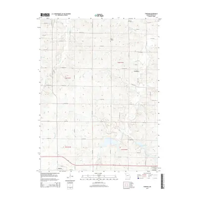
2015 Map of Fordham
USGS Topo · Published 2015About this map
Fordham and the outskirts of Cameron anchor this Missouri landscape where the headwaters of numerous creeks carve through the terrain of DeKalb and Clinton counties. The area is defined by a dendritic drainage pattern including Grindstone Cr, Owens Cr, and W Fork Lost Cr, which are interspersed with various man-made reservoirs like Cameron Reservoir Number 2. Small rural settlements and burial grounds such as Redman Cemetery and Mount Pleasant Cemetery reflect the long-standing agricultural community. In the southern portion of the sheet, the town of Osborn sits along a major transit corridor, showing the intersection of local roads like Harris St with the regional grid. The map reveals how water management transformed the landscape, visible in the numerous numbered impoundments such as B-36 Lake and A-27 Lake that dot the countryside.
Find a feature on this map
54 named features on this map. Tap any name to fly to it.
Don’t see what you’re looking for? This feature index may not catch every label — zoom into the map to look around manually.
Map Details
Editions of this 2015 Fordham Map
This is the sole edition of this map. No revisions or reprints were ever made.
Other maps of this area

1923 · Maysville
USGS Topo · 1:62,500

1924 · Polo
USGS Topo · 1:62,500

1924 · Winston
USGS Topo · 1:62,500

1925 · Plattsburg
USGS Topo · 1:62,500

1925 · Maysville
USGS Topo · 1:62,500

1950 · Kansas City
USGS Topo · 1:250,000

1954 · Kansas City
USGS Topo · 1:250,000

1956 · Kansas City
USGS Topo · 1:250,000

1960 · Kansas City
USGS Topo · 1:250,000
1983 · Maysville
USGS Topo · 1:24,000