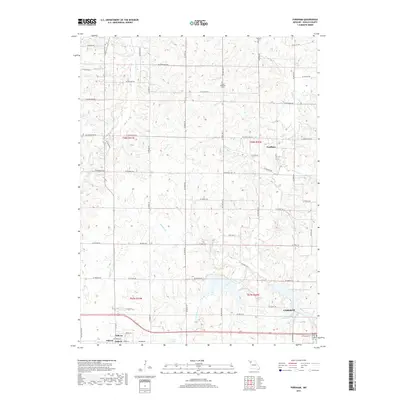
2017 Map of Fordham
USGS Topo · Published 2017About this map
The town of Cameron and the smaller settlement of Osborn anchor the southern portion of this DeKalb County landscape, where the prairie begins to break into the drainage systems of northwestern Missouri. In the early 21st century, the area's geography is defined by a network of creeks, including Grindstone Cr and Wamsley Cr, which feed into local water management features such as Cameron Reservoir Number 2 and Cameron Number 1 Reservoir. The small community of Fordham remains a central landmark in the eastern section of the quadrangle.
Find a feature on this map
63 named features on this map. Tap any name to fly to it.
Don’t see what you’re looking for? This feature index may not catch every label — zoom into the map to look around manually.
Map Details
Editions of this 2017 Fordham Map
This is the sole edition of this map. No revisions or reprints were ever made.
Other maps of this area

1923 · Maysville
USGS Topo · 1:62,500

1924 · Polo
USGS Topo · 1:62,500

1924 · Winston
USGS Topo · 1:62,500

1925 · Plattsburg
USGS Topo · 1:62,500

1925 · Maysville
USGS Topo · 1:62,500

1950 · Kansas City
USGS Topo · 1:250,000

1954 · Kansas City
USGS Topo · 1:250,000

1956 · Kansas City
USGS Topo · 1:250,000

1960 · Kansas City
USGS Topo · 1:250,000
1983 · Maysville
USGS Topo · 1:24,000