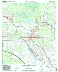
1998 Map of Fordoche
USGS Topo · Published 2002About this map
Bayou Grosse Tete and Bayou Maringouin wind through this landscape of the Atchafalaya basin, defining a region where water management and mineral extraction coexist. The map captures the significant petroleum footprint of the late 20th century, dominated by the Fordoche Oil Field, Livonia Oil Field, and Grosse Tete Oil Field. Settlement is concentrated along the higher ground of the bayous, where communities like Fordoche, Livonia, and Valverda are established alongside a network of drainage canals and levees. Local history is anchored by several rural landmarks, including the Indian Mound near Livonia and the Valverda Sch. Numerous churches and cemeteries, such as Sunlight Ch Cem and Mt Pilgrim Ch, are scattered throughout the agricultural and oil-producing tracts. To the southwest, the Protection Levee marks the boundary of the Atchafalaya National Wildlife Refuge, illustrating the intersection of industrial development and conservation.
Find a feature on this map
41 named features on this map. Tap any name to fly to it.
Don’t see what you’re looking for? This feature index may not catch every label — zoom into the map to look around manually.
Map Details
Editions of this 1998 Fordoche Map
This is the sole edition of this map. No revisions or reprints were ever made.
Other maps of this area

1906 · Bayou Sara
USGS Topo · 1:125,000

1935 · Osca Bayou
USGS Topo · 1:62,500

1939 · Fordoche
USGS Topo · 1:62,500

1940 · Grosse Tete
USGS Topo · 1:62,500

1953 · Maringouin
USGS Topo · 1:24,000

1953 · New Roads
USGS Topo · 1:24,000

1954 · Fordoche
USGS Topo · 1:24,000

1954 · Erwinville
USGS Topo · 1:24,000

1954 · Grosse Tete
USGS Topo · 1:24,000

1954 · Baton Rouge
USGS Topo · 1:250,000