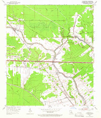
1954 Map of Fordoche
USGS Topo · Published 1966About this map
Fordoche and Livonia serve as the primary nodes of settlement in this part of Pointe Coupee Parish during the mid-1950s. The landscape is defined by the sinuous path of Grosse Tete and Bayou Fordoche, which dictate the placement of farms and small communities like Valverda and Frisco. The arrival of the Texas and Pacific and Missouri Pacific railroads created a secondary industrial layer over the bayou-driven topography, supporting extractive activities at the Lottie Oil Field and the local Gas Field. To the west, the Atchafalaya Floodway and its Protection Levee mark a stark boundary where the natural swamp is managed by engineered barriers. Cultural landmarks like Sunlight Ch and the Bailey Cem provide specific points of interest for those tracing the history of these established bayou communities.
Find a feature on this map
34 named features on this map. Tap any name to fly to it.
Don’t see what you’re looking for? This feature index may not catch every label — zoom into the map to look around manually.
Map Details
Editions of this 1954 Fordoche Map
2 editions found
Other maps of this area

1906 · Bayou Sara
USGS Topo · 1:125,000

1935 · Osca Bayou
USGS Topo · 1:62,500

1939 · Fordoche
USGS Topo · 1:62,500

1940 · Grosse Tete
USGS Topo · 1:62,500

1953 · Maringouin
USGS Topo · 1:24,000

1953 · New Roads
USGS Topo · 1:24,000

1954 · Fordoche
USGS Topo · 1:24,000

1954 · Erwinville
USGS Topo · 1:24,000

1954 · Grosse Tete
USGS Topo · 1:24,000

1954 · Baton Rouge
USGS Topo · 1:250,000