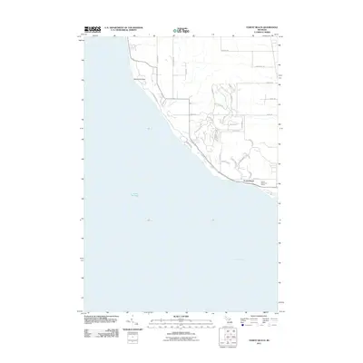
2011 Map of Forest Beach
USGS Topo · Published 2011About this map
Lake Michigan dominates the western half of this coastal area, meeting the shoreline at Sevenmile Point before sweeping southeast into Little Traverse Bay. The landscape is defined by the transition from rural agricultural roads to modern recreational developments. To the north, the terrain is partitioned by a grid of named routes like Wressel Rd and Heynig Rd, while the southern portion reveals the dense, winding residential patterns of Forest Beach. Local landmarks such as the Harbor Point Golf Course and the path of Fivemile Creek illustrate the intersection of natural drainage and coastal land use. The road network, including the curving Lower Shore Dr, follows the contours of the shoreline, highlighting the area's development as a waterfront community during the early 21st century.
Find a feature on this map
38 named features on this map. Tap any name to fly to it.
Don’t see what you’re looking for? This feature index may not catch every label — zoom into the map to look around manually.
Map Details
Editions of this 2011 Forest Beach Map
This is the sole edition of this map. No revisions or reprints were ever made.
Other maps of this area

1955 · Cheboygan
USGS Topo · 1:250,000

1958 · Cheboygan
USGS Topo · 1:250,000

1958 · Cross Village
USGS Topo · 1:62,500

1958 · Pellston
USGS Topo · 1:62,500

1958 · Bayshore
USGS Topo · 1:62,500

1958 · Petoskey
USGS Topo · 1:62,500

1975 · Petoskey NW
USGS Topo · 1:24,000

1975 · Petoskey SW
USGS Topo · 1:24,000

1982 · Petoskey
USGS Topo · 1:100,000
1982 · Good Hart
USGS Topo · 1:25,000