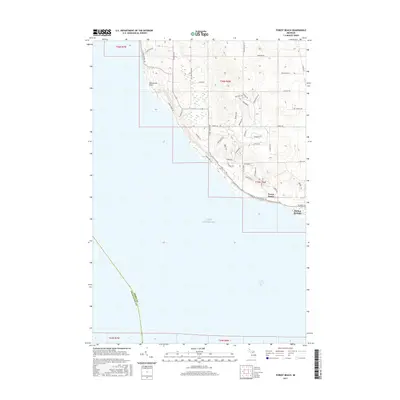
2017 Map of Forest Beach
USGS Topo · Published 2017About this map
Sevenmile Point juts into the cold waters of Lake Michigan along this shoreline in Emmet County, where the coastal landscape is defined by the steep bluffs of the Little Traverse Bay region. The residential and resort character of the area is evident in the dense network of private drives and seasonal roads, such as Surfwood Dr and Birchwood Dr, which wind through the wooded elevations above the lake. Near the southern edge of the sheet, the community of Harbor Springs sits adjacent to the water, while the settlement of Forest Beach occupies the high ground to the north. Inland, Fivemile Cr drains the interior hills, cutting through the terrain before meeting the beach. This modern topographic survey by the U.S. Geological Survey preserves the 21st-century footprint of these Lake Michigan communities, documenting the established property lines and road systems that shape this part of the northern Lower Peninsula.
Find a feature on this map
80 named features on this map. Tap any name to fly to it.
Don’t see what you’re looking for? This feature index may not catch every label — zoom into the map to look around manually.
Map Details
Editions of this 2017 Forest Beach Map
This is the sole edition of this map. No revisions or reprints were ever made.
Other maps of this area

1955 · Cheboygan
USGS Topo · 1:250,000

1958 · Cheboygan
USGS Topo · 1:250,000

1958 · Cross Village
USGS Topo · 1:62,500

1958 · Pellston
USGS Topo · 1:62,500

1958 · Bayshore
USGS Topo · 1:62,500

1958 · Petoskey
USGS Topo · 1:62,500

1975 · Petoskey NW
USGS Topo · 1:24,000

1975 · Petoskey SW
USGS Topo · 1:24,000

1982 · Petoskey
USGS Topo · 1:100,000
1982 · Good Hart
USGS Topo · 1:25,000