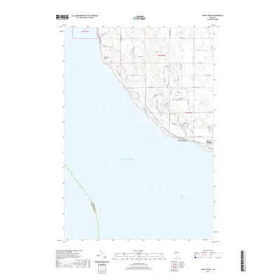
2019 Map of Forest Beach
USGS Topo · Published 2019About this map
The coastal bluffs and northern woods of Emmet County overlook the clear waters of Lake Michigan in this 2019 survey. The landscape is defined by the sharp transition from the elevated terrain of Sevenmile Point down to the shoreline where residential developments like Forest Beach and the western edge of Harbor Springs sit. This era shows a network of winding roads and trails, such as Trillium Trl and Windemere Dr, which have been carved into the forested hills to provide access to seasonal and year-round homes.
Find a feature on this map
56 named features on this map. Tap any name to fly to it.
Don’t see what you’re looking for? This feature index may not catch every label — zoom into the map to look around manually.
Map Details
Editions of this 2019 Forest Beach Map
This is the sole edition of this map. No revisions or reprints were ever made.
Other maps of this area

1955 · Cheboygan
USGS Topo · 1:250,000

1958 · Cheboygan
USGS Topo · 1:250,000

1958 · Cross Village
USGS Topo · 1:62,500

1958 · Pellston
USGS Topo · 1:62,500

1958 · Bayshore
USGS Topo · 1:62,500

1958 · Petoskey
USGS Topo · 1:62,500

1975 · Petoskey NW
USGS Topo · 1:24,000

1975 · Petoskey SW
USGS Topo · 1:24,000

1982 · Petoskey
USGS Topo · 1:100,000
1982 · Good Hart
USGS Topo · 1:25,000