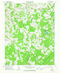
1965 Map of Forest
USGS Topo · Published 1967About this map
Thomas Jefferson’s private retreat, Poplar Forest, anchors this landscape during a period of transition between the traditional rural Piedmont and growing suburban footprints. The mid-1960s terrain is marked by a dense network of country congregations and cemeteries, such as Terrace View Ch and the Callaway-Steptoe Cem, reflecting deep-rooted family ties in the Bedford Co and Campbell Co borderlands.
Find a feature on this map
36 named features on this map. Tap any name to fly to it.
Don’t see what you’re looking for? This feature index may not catch every label — zoom into the map to look around manually.
Map Details
Editions of this 1965 Forest Map
4 editions found
Other maps of this area

1892 · Lynchburg
USGS Topo · 1:125,000

1944 · Lynchburg
USGS Topo · 1:62,500

1947 · Roanoke
USGS Topo · 1:250,000

1950 · Goode
USGS Topo · 1:62,500

1950 · Lynchburg
USGS Topo · 1:62,500

1951 · Altavista
USGS Topo · 1:62,500

1956 · Gladys
USGS Topo · 1:62,500

1959 · Roanoke
USGS Topo · 1:250,000

1963 · Roanoke
USGS Topo · 1:250,000

1963 · City Farm
USGS Topo · 1:24,000