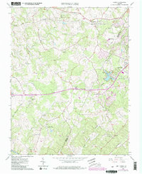
1965 Map of Forest
USGS Topo · Published 1986About this map
Poplar Forest and the surrounding Bedford County landscape appear here in a period of transition during the mid-1960s. The map illustrates a rural interior defined by its faith and education, anchored by institutions like the New London Academy and numerous small houses of worship including Forest Level Ch, Pisgah Ch, and Mt Moriah Ch. Transport networks of the Norfolk and Western and the Southern railways bisect the terrain, connecting the rural communities of Bellevue and Forest to the growing industrial periphery of Lynchburg.
Find a feature on this map
34 named features on this map. Tap any name to fly to it.
Don’t see what you’re looking for? This feature index may not catch every label — zoom into the map to look around manually.
Map Details
Editions of this 1965 Forest Map
4 editions found
Other maps of this area

1892 · Lynchburg
USGS Topo · 1:125,000

1944 · Lynchburg
USGS Topo · 1:62,500

1947 · Roanoke
USGS Topo · 1:250,000

1950 · Goode
USGS Topo · 1:62,500

1950 · Lynchburg
USGS Topo · 1:62,500

1951 · Altavista
USGS Topo · 1:62,500

1956 · Gladys
USGS Topo · 1:62,500

1959 · Roanoke
USGS Topo · 1:250,000

1963 · Roanoke
USGS Topo · 1:250,000

1963 · City Farm
USGS Topo · 1:24,000