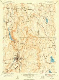
1949 Map of Forest City
USGS Topo · Published 1949About this map
The rugged topography of the Moosic Mountains dominates this mid-century survey, dividing the landscape into distinct river valleys that shaped local settlement and transit. Forest City stands as the primary hub at the southwestern edge of the sheet, served by the Forest City Sta and supported by the nearby residential pockets of Vandling and Richmondale. The historical importance of the Old Newburgh Turnpike is evident as it cuts through the north, passing Belmont Corner and Pleasant Mount. Along the western corridor, the Erie RR and the New York Ontario and Western RR trace the East Branch Lackawanna River valley, passing through Uniondale. Significant water management is highlighted by the Stillwater Reservoir and White Oak Pond, while community life centers around landmarks like the Maple Grove Ch, St James Cem, and the Curtis Valley Sch.
Find a feature on this map
45 named features on this map. Tap any name to fly to it.
Don’t see what you’re looking for? This feature index may not catch every label — zoom into the map to look around manually.
Map Details
Editions of this 1949 Forest City Map
2 editions found
Other maps of this area

1892 · Honesdale
USGS Topo · 1:62,500

1892 · Dundaff
USGS Topo · 1:62,500

1926 · Starrucca
USGS Topo · 1:62,500

1930 · Starrucca
USGS Topo · 1:48,000

1932 · Susquehanna
USGS Topo · 1:62,500

1933 · Starrucca
USGS Topo · 1:62,500

1935 · Susquehanna
USGS Topo · 1:62,500

1943 · Honesdale
USGS Topo · 1:125,000

1946 · Forest City
USGS Topo · 1:24,000

1946 · Carbondale
USGS Topo · 1:24,000