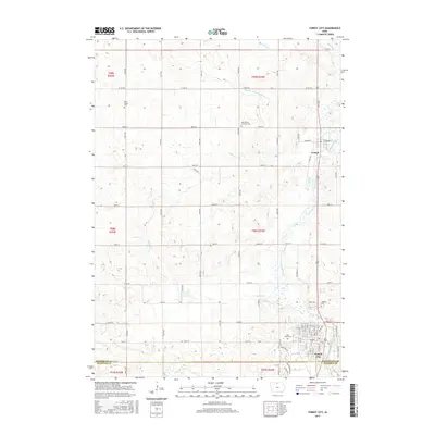
2015 Map of Forest City
USGS Topo · Published 2015About this map
Forest City serves as the primary hub at the southern edge of this Winnebago County survey, where the Winnebago River winds through the landscape. The layout of the region is defined by a rigorous grid of section lines and county roads, including Co Rd A36 and Co Rd A44, which connect the town to the smaller village of Leland. This geography reflects the agricultural foundations of northern Iowa, with scattered rural burial grounds like West Prairie Cem and West Prairie Lutheran Cem preserved among the fields. Water management is a central theme of the terrain, visible in the engineered path of Drainage Ditch Number 11 and the natural meanders of Buffalo Cr. Within the city limits, landmarks such as Oakland Cem and Saint James Cem provide clear points of reference for local historians and genealogists tracing early residents of the area.
Find a feature on this map
33 named features on this map. Tap any name to fly to it.
Don’t see what you’re looking for? This feature index may not catch every label — zoom into the map to look around manually.
Map Details
Editions of this 2015 Forest City Map
This is the sole edition of this map. No revisions or reprints were ever made.
Other maps of this area

1954 · Mason City
USGS Topo · 1:250,000

1957 · Mason City
USGS Topo · 1:250,000

1958 · Mason City
USGS Topo · 1:250,000

1972 · Forest City
USGS Topo · 1:24,000

1972 · Buffalo Center NE
USGS Topo · 1:24,000

1972 · Hayfield
USGS Topo · 1:24,000

1972 · Crystal Lake
USGS Topo · 1:24,000

1972 · Pilot Knob
USGS Topo · 1:24,000

1972 · Vinje
USGS Topo · 1:24,000
1972 · Thompson
USGS Topo · 1:24,000