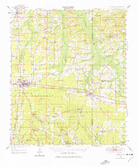
1950 Map of Forest
USGS Topo · Published 1976About this map
Forest serves as a central hub on this 1950 revision, where the Illinois Central Gulf Railroad and a prominent gas pipe line traverse the landscape. Much of the region is integrated into the Bienville National Forest, characterized by a dense network of small rural settlements and religious centers such as Singleton Settlement, Usrytown, and Donohoe. The topography is defined by numerous watercourses, including Tuscolameta Creek and Tallahala Creek, which drain the varied terrain marked by local landmarks like Harrell Prairie Hill and Diamond Hill.
Find a feature on this map
81 named features on this map. Tap any name to fly to it.
Don’t see what you’re looking for? This feature index may not catch every label — zoom into the map to look around manually.
Map Details
Editions of this 1950 Forest Map
2 editions found
Other maps of this area

1921 · Forest
USGS Topo · 1:48,000

1922 · Forest
USGS Topo · 1:62,500

1922 · Morton
USGS Topo · 1:48,000

1924 · Morton
USGS Topo · 1:62,500

1950 · Forest
USGS Topo · 1:62,500

1951 · Morton
USGS Topo · 1:62,500

1952 · Forest
USGS Topo · 1:62,500

1953 · Meridian
USGS Topo · 1:250,000

1957 · Meridian
USGS Topo · 1:250,000

1961 · Carthage
USGS Topo · 1:62,500