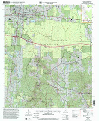
2000 Map of Forest
USGS Topo · Published 2002About this map
The Bienville National Forest dominates the southern half of this Scott County landscape, where the mixed woodland is punctuated by family and community landmarks. The town of Forest serves as the regional hub, situated along the Kansas City Southern railroad line and home to civic institutions like High School, Hawkins School, and Lake Hospital. A network of rural communities and crossroads, including Norris and Fikestown, are connected by winding roads and light-duty paths through the timberlands.
Find a feature on this map
47 named features on this map. Tap any name to fly to it.
Don’t see what you’re looking for? This feature index may not catch every label — zoom into the map to look around manually.
Map Details
Editions of this 2000 Forest Map
This is the sole edition of this map. No revisions or reprints were ever made.
Other maps of this area

1921 · Forest
USGS Topo · 1:48,000

1922 · Forest
USGS Topo · 1:62,500

1922 · Morton
USGS Topo · 1:48,000

1924 · Morton
USGS Topo · 1:62,500

1950 · Forest
USGS Topo · 1:62,500

1951 · Morton
USGS Topo · 1:62,500

1952 · Forest
USGS Topo · 1:62,500

1953 · Meridian
USGS Topo · 1:250,000

1957 · Meridian
USGS Topo · 1:250,000

1965 · Meridian
USGS Topo · 1:250,000