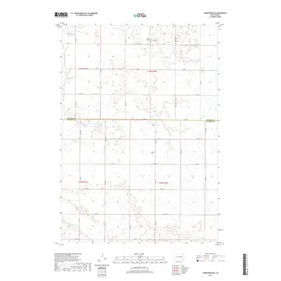
2017 Map of Forestburg NE
USGS Topo · Published 2017About this map
Bonny Cem stands as a quiet focal point in the southern half of this landscape, situated within a region defined by the winding course of the James River and its varied tributaries. The drainage patterns of the Glacial Lake Dakota plain are clearly visible through the networks of Pearl Cr, S Fork Pearl Cr, and Marsh Cr, which carve through the township sections. This area, spanning the border of Beadle and Sanborn Counties, reflects a strictly organized grid of section lines and rural roads such as Co Rd 12 and Co Rd 15. Cultural markers are sparse but significant, including the Ingle Airport in the northern reaches, illustrating the adaptation of modern aviation into a traditional agricultural prairie setting. The inclusion of Stony Run further details the local hydrology that has historically dictated land use and settlement in this part of South Dakota.
Find a feature on this map
24 named features on this map. Tap any name to fly to it.
Don’t see what you’re looking for? This feature index may not catch every label — zoom into the map to look around manually.
Map Details
Editions of this 2017 Forestburg NE Map
This is the sole edition of this map. No revisions or reprints were ever made.
Other maps of this area

1898 · Huron
USGS Topo · 1:125,000

1899 · De Smet
USGS Topo · 1:125,000

1953 · Huron
USGS Topo · 1:250,000

1953 · Watertown
USGS Topo · 1:250,000

1954 · Huron
USGS Topo · 1:250,000

1957 · Forestburg NE
USGS Topo · 1:24,000
1957 · Forestburg
USGS Topo · 1:24,000

1957 · Cavour
USGS Topo · 1:24,000

1957 · Huron
USGS Topo · 1:24,000

1958 · Watertown
USGS Topo · 1:250,000