
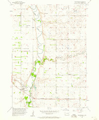
1957 Map of Forestburg NE
USGS Topo · Published 1958About this map
James River and its meandering tributaries define this mid-century landscape along the border of Beadle and Sanborn counties. The rural community structure of the late 1950s is remarkably clear, centered around a network of country schools including Pearl Sch, Oldenburg Sch, Rhodes Sch, and Maurer Sch. The map records a shift in the local social geography, marking both the Community Hall and the status of several properties like Flagel Sch and Center Sch as abandoned. These details, alongside the Pearl Ch and Bonny Cem, provide a precise record of the prairie township system during a period of transition for family farms in the Missouri River Basin development area. Natural drainage features like Stony Run and the South Fork Pearl Creek cut through the sections, punctuating a landscape of scattered gravel pits and rural homesteads.
Find a feature on this map
20 named features on this map. Tap any name to fly to it.
Don’t see what you’re looking for? This feature index may not catch every label — zoom into the map to look around manually.
Map Details
Editions of this 1957 Forestburg NE Map
This is the sole edition of this map. No revisions or reprints were ever made.
Other maps of this area

1898 · Huron
USGS Topo · 1:125,000

1899 · De Smet
USGS Topo · 1:125,000

1953 · Huron
USGS Topo · 1:250,000

1953 · Watertown
USGS Topo · 1:250,000

1954 · Huron
USGS Topo · 1:250,000
1957 · Forestburg
USGS Topo · 1:24,000

1957 · Cavour
USGS Topo · 1:24,000

1957 · Huron
USGS Topo · 1:24,000

1958 · Watertown
USGS Topo · 1:250,000

1958 · Forestburg NW
USGS Topo · 1:24,000