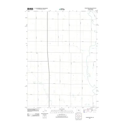
2012 Map of Forestburg NW
USGS Topo · Published 2012About this map
James River meanders across the eastern portion of this Sanborn County landscape, carving a distinct riparian corridor through the grid of agricultural sections. The terrain is defined by the intersection of rural thoroughfares such as 220th St and 401st Ave, reflecting the systematic settlement patterns of the Great Plains. Cultural and genealogical interest centers on the Aquilla Cem, a quiet landmark located just west of the river near the center of the survey. The hydrology of the area is further shaped by Stony Run in the northeast and the winding path of Sand Cr in the southwest, illustrating the drainage system that supports the region's prairie farmsteads.
Find a feature on this map
18 named features on this map. Tap any name to fly to it.
Don’t see what you’re looking for? This feature index may not catch every label — zoom into the map to look around manually.
Map Details
Editions of this 2012 Forestburg NW Map
This is the sole edition of this map. No revisions or reprints were ever made.
Other maps of this area

1898 · Huron
USGS Topo · 1:125,000

1953 · Huron
USGS Topo · 1:250,000

1954 · Huron
USGS Topo · 1:250,000

1957 · Forestburg NE
USGS Topo · 1:24,000
1957 · Forestburg
USGS Topo · 1:24,000

1957 · Cavour
USGS Topo · 1:24,000

1957 · Huron
USGS Topo · 1:24,000

1958 · Forestburg NW
USGS Topo · 1:24,000

1973 · Alpena
USGS Topo · 1:24,000
1973 · Forestburg SW
USGS Topo · 1:24,000