
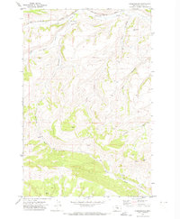
1970 Map of Forestgrove
USGS Topo · Published 1973About this map
Forestgrove sits at a geographic crossroads in the drainage of South Fork McDonald Creek during the late 1960s. The small settlement is defined by its position along the Chicago Milwaukee St Paul and Pacific railroad line, which skirts the northern edge of the terrain near a local Cem. The landscape transitions from the rail-serviced valley floors to the high elevations of McDonald Butte and the winding depths of Rose Canyon. Numerous drainages such as Surenough Creek, Tyler Creek, and Bear Creek carve through the area, indicating a region shaped by complex water rights and historical cattle or sheep ranching. This 1970 field-checked survey captures the rural infrastructure of central Montana, showing the network of unimproved roads that connected these remote homesteads and watersheds before modern development.
Find a feature on this map
13 named features on this map. Tap any name to fly to it.
Don’t see what you’re looking for? This feature index may not catch every label — zoom into the map to look around manually.
Map Details
Editions of this 1970 Forestgrove Map
2 editions found
Other maps of this area

1889 · Big Snowy Mountain
USGS Topo · 1:250,000

1893 · Big Snowy Mountain
USGS Topo · 1:250,000

1941 · Judith Peak
USGS Topo · 1:62,500

1944 · Judith Peak
USGS Topo · 1:62,500

1954 · Roundup
USGS Topo · 1:250,000

1954 · Lewistown
USGS Topo · 1:250,000

1958 · Roundup
USGS Topo · 1:250,000

1959 · Lewistown
USGS Topo · 1:250,000

1970 · South Bench
USGS Topo · 1:24,000
1970 · Alaska Bench
USGS Topo · 1:24,000