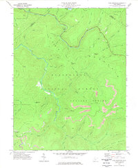
1977 Map of Fork Mountain
USGS Topo · Published 1978About this map
Monongahela National Forest dominates this topographic view of the Greenbrier highlands, where the North Fork Cherry River and South Fork Cherry River converge. The landscape is defined by the extraction economy of the 1970s, evidenced by a series of Strip Mine operations carved into the ridges above Falling Spring. These industrial scars contrast with the recreation-focused Summit Lake and the North Bend Roadside Park along the river's edge. Local genealogy and land-use history are anchored by family-named landmarks like Manning Knob and Bearwallow Knob, along with a small Cem tucked near the Williamsburg boundary. The map provides a clear record of the area's timber and coal-driven topography before later reclamation efforts changed the profile of the surrounding benches like Sugartree Bench.
Find a feature on this map
63 named features on this map. Tap any name to fly to it.
Don’t see what you’re looking for? This feature index may not catch every label — zoom into the map to look around manually.
Map Details
Editions of this 1977 Fork Mountain Map
2 editions found
Other maps of this area

1889 · Nicholas
USGS Topo · 1:125,000

1891 · Nicholas
USGS Topo · 1:125,000

1891 · Huntersville
USGS Topo · 1:125,000

1894 · Huntersville
USGS Topo · 1:125,000

1901 · Nicholas
USGS Topo · 1:125,000

1915 · Webster Springs
USGS Topo · 1:48,000

1915 · Cowen
USGS Topo · 1:48,000

1917 · Cowen
USGS Topo · 1:62,500

1918 · Webster Springs
USGS Topo · 1:62,500

1918 · Richwood
USGS Topo · 1:62,500