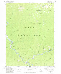
1978 Map of Forks of Salmon
USGS Topo · Published 1984About this map
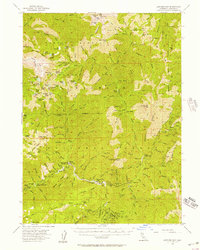
Forks of Salmon marks the confluence of the north and south forks within the rugged Klamath Mountains, serving as a focal point for gold mining activity and forest management in the 1970s. The settlement pattern here follows the riverbanks, where names like Fong Wah Bar, Brazille Flat, and Mc Neal Bar indicate historical mining claims and family-named landings. Remote lode and placer operations are scattered throughout the steep drainages, including the Sauerkraut Mine, Bloomer Mine, and the Forest and Stout Mine along the South Fork Salmon River. Extensive trail systems like the Pack Trail and Jeep Trail navigate the terrain toward the Marble Mountain Wilderness, connecting isolated landmarks such as Indian Point and Crapo Ridge. The presence of the USFS Station and local burying grounds like Bennett Cem reflect the enduring role of the Forest Service and small mountain communities in this corner of the Klamath National Forest.
Find a feature on this map
81 named features on this map. Tap any name to fly to it.
Don’t see what you’re looking for? This feature index may not catch every label — zoom into the map to look around manually.
Map Details
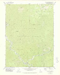
Editions of this 1978 Forks of Salmon Map
2 editions found
Other maps of this area

1948 · Weed
USGS Topo · 1:250,000

1950 · Weed
USGS Topo · 1:250,000
1955 · Salmon Mtn
USGS Topo · 1:62,500
1955 · Cecilville
USGS Topo · 1:62,500
1955 · Sawyers Bar
USGS Topo · 1:62,500
1955 · Forks of Salmon
USGS Topo · 1:62,500

1958 · Weed
USGS Topo · 1:250,000

1963 · Weed
USGS Topo · 1:250,000
1974 · Orleans Mtn.
USGS Topo · 1:24,000
1977 · English Peak
USGS Topo · 1:24,000