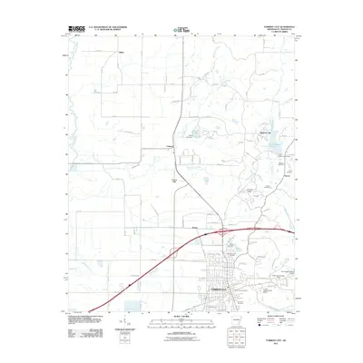
2011 Map of Forrest City
USGS Topo · Published 2011About this map
Forrest City serves as the focal point of this Eastern Arkansas landscape, situated along the distinct geological rise of Crowley Ridge. The terrain transitions from the low-lying bottomlands of the L'Anguille River in the west to the elevated ridge that dictates the placement of older settlements and cemeteries. Local history is anchored by sites like Mount Vernon Cemetery and Forrest City Cemetery, while smaller rural communities such as Shiloh, Union Hill, and Rosine dot the outlying areas. The region's water management is evident in the series of reservoirs and dams, including Telico Lake, Hickey Lake, and Lake Saint Francis, which provide recreation and irrigation for the surrounding agricultural tracts. The map captures the intersection of major transportation corridors with the natural winding paths of Big Telico Creek and Crow Creek, illustrating how the modern infrastructure follows the older contours of the ridge.
Find a feature on this map
113 named features on this map. Tap any name to fly to it.
Don’t see what you’re looking for? This feature index may not catch every label — zoom into the map to look around manually.
Map Details
Editions of this 2011 Forrest City Map
This is the sole edition of this map. No revisions or reprints were ever made.
Other maps of this area

1939 · Park Place
USGS Topo · 1:62,500

1939 · Wynne
USGS Topo · 1:62,500

1940 · Whitmore
USGS Topo · 1:62,500

1940 · Marianna
USGS Topo · 1:62,500

1948 · Helena
USGS Topo · 1:250,000

1950 · Helena
USGS Topo · 1:250,000

1953 · Memphis
USGS Topo · 1:250,000

1955 · Park Place
USGS Topo · 1:62,500

1955 · Helena
USGS Topo · 1:250,000

1956 · Memphis
USGS Topo · 1:250,000