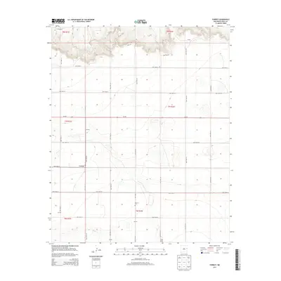
2013 Map of Forrest
USGS Topo · Published 2013About this map
The high plains of the Llano Estacado define this portion of Quay County, where the settlement of Forrest serves as a central point for a grid of rural routes. The landscape transition is marked by the sharp relief of northern mesas near Lindsey, while the southern reaches are drained by the intermittent paths of Blanco Cr and Frio Draw. This 2013 survey illustrates a specialized agricultural and ranching geography characterized by widely spaced homesteads and named locales such as Kitchens, Wagley, and Mitchell. Local history and genealogy are anchored by the Beevers Cem, situated near the small community of Beevers. The dominance of the section-line road system, including Nm-209, underscores the organized land management of eastern New Mexico's ranching country.
Find a feature on this map
30 named features on this map. Tap any name to fly to it.
Don’t see what you’re looking for? This feature index may not catch every label — zoom into the map to look around manually.
Map Details
Editions of this 2013 Forrest Map
This is the sole edition of this map. No revisions or reprints were ever made.
Other maps of this area

1954 · Clovis
USGS Topo · 1:250,000

1957 · Hammond Ranch
USGS Topo · 1:62,500

1958 · Clovis
USGS Topo · 1:250,000

1971 · Ragland
USGS Topo · 1:24,000
1971 · Mesa Redonda
USGS Topo · 1:24,000
1971 · Apache Canyon
USGS Topo · 1:24,000
1971 · Norton
USGS Topo · 1:24,000

1971 · Grady SW
USGS Topo · 1:24,000

1971 · Forrest
USGS Topo · 1:24,000

1973 · Weber City
USGS Topo · 1:24,000