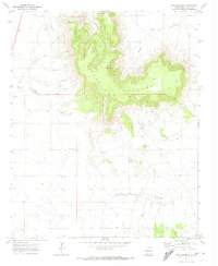
1971 Map of Mesa Redonda
USGS Topo · Published 1974About this map
Mesa Redonda rises as the dominant landform in this high-plains landscape south of Tucumcari, defining the drainage patterns of the surrounding ranching country. This 1971 field-checked survey reveals a sparse network of water sources and seasonal drainages, including Apodaca Creek and the deep cut of Spikes Canyon to the west, while Barranca Creek winds through the southern reaches. The plateau itself is accessed by a series of primitive routes, notably a Pack Trail and Jeep Trail that climb the steep escarpment toward a high-elevation Corral. Human impact on the land is represented by scattered industrial and agricultural markers, such as a Gravel Pit and several Drill Holes, reflecting the region's reliance on groundwater and mineral resources. The map documents the intricate contouring of the mesa's edge, where Rincon Creek and Puris Creek have carved distinct breaks into the level tableland.
Find a feature on this map
12 named features on this map. Tap any name to fly to it.
Don’t see what you’re looking for? This feature index may not catch every label — zoom into the map to look around manually.
Map Details
Editions of this 1971 Mesa Redonda Map
This is the sole edition of this map. No revisions or reprints were ever made.
Other maps of this area

1930 · Tucumcari
USGS Topo · 1:125,000

1954 · Tucumcari
USGS Topo · 1:250,000

1954 · Clovis
USGS Topo · 1:250,000

1958 · Clovis
USGS Topo · 1:250,000

1958 · Tucumcari
USGS Topo · 1:250,000

1968 · Bulldog Mesa
USGS Topo · 1:24,000
1968 · Briscoe Ranch
USGS Topo · 1:24,000
1968 · Tucumcari SE
USGS Topo · 1:24,000

1970 · Jordan
USGS Topo · 1:24,000

1970 · Quay
USGS Topo · 1:24,000