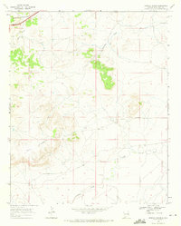
1968 Map of Briscoe Ranch
USGS Topo · Published 1971About this map
Quemado Mesa dominates the southern landscape of this rangeland survey, illustrating the high-desert terrain of Quay County in the late 1960s. The map centers on the Briscoe Ranch, a focal point of local activity in an area defined by intermittent drainages and isolated water sources like Dyer Well. The northwestern corner is clipped by the steel rails of the Chicago Rock Island and Pacific railroad, which provided the primary industrial connection for this ranching district. A network of primitive roads and a Jeep Trail snake through the drainage basins of Blanca Creek, Bluewater Creek, and Charco Creek, revealing the sparse but functional infrastructure required to manage livestock across these expansive mesa lands.
Find a feature on this map
11 named features on this map. Tap any name to fly to it.
Don’t see what you’re looking for? This feature index may not catch every label — zoom into the map to look around manually.
Map Details
Editions of this 1968 Briscoe Ranch Map
2 editions found
Other maps of this area

1930 · Tucumcari
USGS Topo · 1:125,000

1954 · Tucumcari
USGS Topo · 1:250,000

1954 · Clovis
USGS Topo · 1:250,000

1958 · Clovis
USGS Topo · 1:250,000

1958 · Tucumcari
USGS Topo · 1:250,000

1967 · Liberty Mesa
USGS Topo · 1:24,000

1967 · Tucumcari
USGS Topo · 1:24,000
1968 · Quemado Hills
USGS Topo · 1:24,000

1968 · Bulldog Mesa
USGS Topo · 1:24,000
1968 · Cow Canyon
USGS Topo · 1:24,000