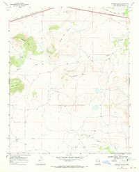
1968 Map of Quemado Hills
USGS Topo · Published 1971About this map
The Chicago Rock Island and Pacific railroad cuts across the northern reaches of this high-plains landscape, serving as the primary corridor through the northeastern corner of New Mexico during the late 1960s. The topography is dominated by dramatic elevations like Mesa Del Puerta and the Quemado Hills, where the land drops away into seasonal drainage systems including Blanca Creek and Charco Creek. A solitary Radio Tower and a Borrow Pit near the tracks suggest the light footprint of industrial infrastructure in an otherwise open range. The presence of a Spring and numerous fence lines point to the region's ranching activity, with the survey capturing the physical boundaries of land use between Palomas Mesa and the surrounding flats.
Find a feature on this map
11 named features on this map. Tap any name to fly to it.
Don’t see what you’re looking for? This feature index may not catch every label — zoom into the map to look around manually.
Map Details
Editions of this 1968 Quemado Hills Map
This is the sole edition of this map. No revisions or reprints were ever made.
Other maps of this area

1930 · Tucumcari
USGS Topo · 1:125,000

1954 · Santa Fe
USGS Topo · 1:250,000

1954 · Fort Sumner
USGS Topo · 1:250,000

1954 · Tucumcari
USGS Topo · 1:250,000

1954 · Clovis
USGS Topo · 1:250,000

1958 · Fort Sumner
USGS Topo · 1:250,000

1958 · Santa Fe
USGS Topo · 1:250,000

1958 · Clovis
USGS Topo · 1:250,000

1958 · Tucumcari
USGS Topo · 1:250,000

1964 · Muniz Canyon
USGS Topo · 1:24,000