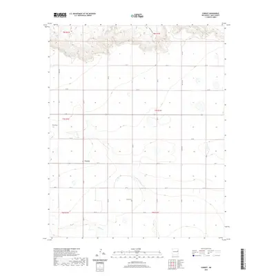
2020 Map of Forrest
USGS Topo · Published 2020About this map
Forrest sits at the intersection of local routes within the high plains of Quay County, defined by a rigid grid of agricultural roads such as Quay Rd Ad and Quay Rd Ae. The landscape is etched by intermittent watercourses, including Frio Draw in the northwest and the winding path of Blanco Cr near the southern boundary. A key point for local history is the Beevers Cem, located south of the central settlement area. The township and range lines, including t7n r31e and t7n r32e, underscore the systematic land partitioning of this ranching and farming region. This survey captures the sparse, wide-open character of eastern New Mexico, where life is organized around these long-distance section roads and the few permanent landmarks that anchor the community.
Find a feature on this map
25 named features on this map. Tap any name to fly to it.
Don’t see what you’re looking for? This feature index may not catch every label — zoom into the map to look around manually.
Map Details
Editions of this 2020 Forrest Map
This is the sole edition of this map. No revisions or reprints were ever made.
Other maps of this area

1954 · Clovis
USGS Topo · 1:250,000

1957 · Hammond Ranch
USGS Topo · 1:62,500

1958 · Clovis
USGS Topo · 1:250,000

1971 · Ragland
USGS Topo · 1:24,000
1971 · Mesa Redonda
USGS Topo · 1:24,000
1971 · Apache Canyon
USGS Topo · 1:24,000
1971 · Norton
USGS Topo · 1:24,000

1971 · Grady SW
USGS Topo · 1:24,000

1971 · Forrest
USGS Topo · 1:24,000

1973 · Weber City
USGS Topo · 1:24,000