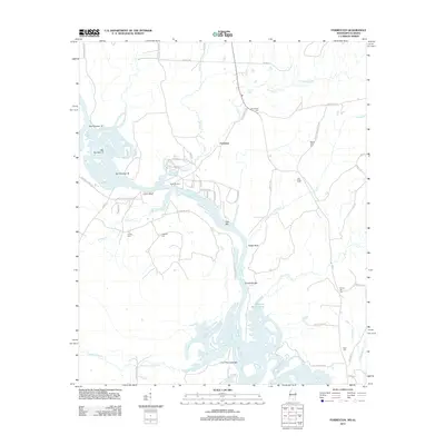
2012 Map of Forreston
USGS Topo · Published 2012About this map
Forreston and Union Bluff anchor this reach of the river valley, where the landscape is defined by the winding hydrology of the waterway and its numerous sandbars. The map documents a complex river system featuring Ellis Bar, Crawfords Bar, and Pettys Bluff, alongside the significant Hairston Bend Cutoff. For genealogists and local historians, the sheet is particularly dense with family-named landmarks and burial sites, including Brookshire Cem, Mount Olive Cem, Oak Ridge Cem, and Toliver Cem. Evidence of historical river transit is preserved in labels like Nashville Ferry and the various branches of Nashville Ferry Rd. The terrain is further dissected by numerous tributaries such as Coal Fire Cr, Broken Pumpkin Cr, and James Cr, reflecting the alluvial character of this Mississippi-Alabama border region.
Find a feature on this map
57 named features on this map. Tap any name to fly to it.
Don’t see what you’re looking for? This feature index may not catch every label — zoom into the map to look around manually.
Map Details
Editions of this 2012 Forreston Map
This is the sole edition of this map. No revisions or reprints were ever made.
Other maps of this area

1953 · West Point
USGS Topo · 1:250,000

1958 · West Point
USGS Topo · 1:250,000

1960 · Columbus
USGS Topo · 1:62,500

1963 · West Point
USGS Topo · 1:250,000

1966 · Ethelsville
USGS Topo · 1:24,000

1966 · Reform SW
USGS Topo · 1:24,000

1970 · Aliceville North
USGS Topo · 1:24,000

1973 · Cliftonville
USGS Topo · 1:24,000
1974 · Pickensville
USGS Topo · 1:24,000

1984 · West Point
USGS Topo · 1:250,000